Forum Archives » Complete » Third Wire Series (SF) » Simulated Aerial View of Ubon
Page 4 of 4 < 1 2 3 4
Topic Options
Hop to:
#1238498 - 06/13/02 04:30 AM Re: Simulated Aerial View of Ubon
DanW Offline
Member

Registered: 10/11/99
Loc: Austin, TX
Fellas,

You can use 'opacity maps' ie, alpha textures in the sim. But it's not a sure fire way to add more buildings. I may be mistaken, but I think rendering alpha textures is more CPU intensive than rendering a normal 24-bit bitmap. Also keep in mind that you now must use a larger texture to show your city block since you are stretching it across a large area of buildings, or otherwise it will be very blurry with a low resolution....so what you save in polygons you loose in having to use more texture memory than you normally would need for you buildings. And, in addition to that, you will have lower resolution buildings to boot

Best way to do something like this is like what TK said. Start small with a few objects, test it, and work your way up. Granted its hard to do this without the game on your harddrive, but we are working hard to solve that part of the problem

Anyways, great ideas and great references....discussion about this kinda stuff is very good to get out in the open.

dan
_________________________
Hook'em Horns


Top Bookmark and Share
#1238499 - 06/13/02 11:58 AM Re: Simulated Aerial View of Ubon
AD Offline
Senior Member

Registered: 10/29/01
Loc: South East Asia
Quote:
The Operation Flashpoint approach to rendering large forests sounds a lot like the method Ajax used to consolidate a whole row or block of buildings into one object.


Well not really, it uses normal tree objects, but they are connected to one ground object..This means that infact you have one very large object the game has to track, collision detect etc.

I made a quick test keeping polys as low as possible but attempting to get quite thick coverage.


It doesn't look like much and is missing textures.

There is rougly 1300 polys in this scene, all the tree objects are connected to the ground plane. You can see the outer "ring" has less objects. The concept is that as you fly closer the outer ring becomes as detailed as the inner ring and the object you just flew over becomes less detailed etc.

This is the only way I can think of making a viable forest.
_________________________
"One thing puzzles me Baldrick, how did you manage to get so much custard out of such a small cat?"


Top Bookmark and Share

#1238500 - 06/13/02 05:51 PM Re: Simulated Aerial View of Ubon
Anonymous
Unregistered

Quote:
Originally posted by Armourdave:
I made a quick test keeping polys as low as possible but attempting to get quite thick coverage. It doesn't look like much and is missing textures.

There is rougly 1300 polys in this scene, all the tree objects are connected to the ground plane. You can see the outer "ring" has less objects. The concept is that as you fly closer the outer ring becomes as detailed as the inner ring and the object you just flew over becomes less detailed etc.

This is the only way I can think of making a viable forest.


Armourdave:

That's a big step in the right direction! The foliage density is just about right. Assuming that your forest can be viewed from ground level, and that the trees themselves can be textured to look less like triangles without severely impacting the frame rate, it seems to be a good solution to the problem.

I took these screen shots of the Vietnam terrain in MS Flight Simulator 2002. From high altitude (in this case about 15,000 feet), the flat scenery tiles look pretty good to me. Of course, the 3-D objects don't come into play at this height.

(Note: The original .bmp screen shots are much sharper, but they are very large. Therefore, I had to substantially reduce the resolution and compress them into .jpg files in order to post them here. That's why they look fuzzy. They actually look better if you stand at least 5 feet away from your screen.)

Screen shot #1.
Location: About 25 miles northwest of Saigon.


Screen shot #2.
Location: About 10 miles southeast of Hanoi (tailing a Mig-21.)


However, when you get close to ground level, the scenery tiles become blurry. The 3-D trees and other objects become visible at low altitude, but the building textures are primitive and the trees are sparse.

In the following ground level cockpit view of a "forest" near Hue, the 3-D tree density is about as high as it gets. In my opinion, this is an unsatisfactory representation of a forest. Perhaps I'm being too picky because I've been "spoiled" by the near-photographic quality and high density of the 3-D scenery in golf simulators.


Again, your approach to creating a 3-D forest appears to have great potential, especially if we adopt the Lomac approach and limit the rendering of 3-D objects to within 5,000 feet or so vertically and perhaps up to 1 1/2 miles horizontally. That, combined with the building consolidation technique demonstrated by Ajax, should provide excellent terrain realism while keeping the demand on system resources at a reasonable level.

I have one further suggestion, though. Since the borders of forests are rarely straight (except in places where they've been cleared to provide space for human uses), I think it would be better to use both square and triangular 3-D blocks of trees together in various combinations to achieve a more natural looking irregular outline.

(Note: with pentagons or hexagons you could achieve nearly perfect forest contours, but I'm suggesting triangles as a way to do it without increasing the number of sides that have to be rendered.)


[This message has been edited by Sleuths7 (edited 06-15-2002).]

Top Bookmark and Share
#1238501 - 06/14/02 07:40 PM Re: Simulated Aerial View of Ubon
Anonymous
Unregistered

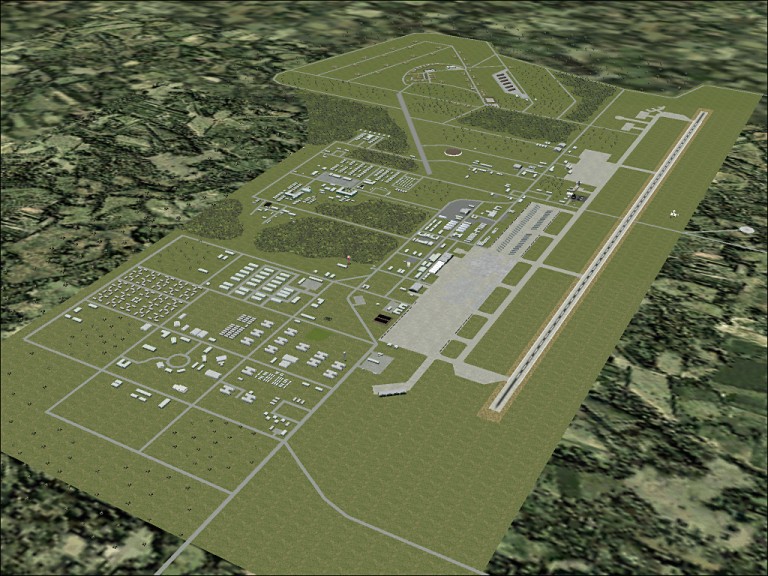
Well, I finally managed to find enough photos to recreate one more Thailand airbase: Udorn.

This one can only be considered a reasonable approximation at best, because there were a few gaps between the photos, which forced me to do some "educated guessing" as to the exact placement of some roads & buildings. This is particularly true of the southern part of the base because the only photo that shows that area was taken from several miles away.

Also, there was a built-up area adjacent to the runway at its southeastern end, but I couldn't tell whether it was part of the base or part of the city of Udorn, so I decided to leave it out for now. (Udorn RTAFB adjoined the southern border of the city.)

The runway numbers at Udorn were 12 and 30. The concrete runway was 10,000 feet long.


I discovered that Udorn, like Ubon, had a semi-circular section of taxiway bordered by maintenance facilities. At Ubon, the maintenance arc wasn't near the flightline, but at Udorn it was right next to it. This was a much more practical and convenient arrangement.

The completeness percentages of the four airbase re-creations that I've done are approximately as follows:

Ubon: 99% (It's not 100% primarily because I deliberately omitted a few minor structures like latrines, guard shacks, telephone booths, etc.)

NKP: 90%
Khorat: 80-85%
Udorn: Probably no more than 60%, but the runway, taxiways, flightline, and most major buildings are correctly represented.

That leaves Takhli and U-Tapao, but I'm afraid they will have to wait until people who served there step forward and offer to help. Although I've been able to find out the layout of the runways, flightlines, etc., there aren't enough photos or maps available to even begin recreating these bases.

Incidentally, the runways at Takhli and U-Tapao both ran north & south (180 & 360). The major difference was length. The runway at Takhli was 9,843' feet long (the same as Ubon and Khorat), but the runway at U-Tapao was 11,499' long, because it had to handle huge B-52 bombers.

NKP had the shortest runway of all the bases in Thailand. It was only 8,202' long, and was originally constructed out of metal plates (PSP). It was later paved with asphalt.

Top Bookmark and Share
#1238502 - 06/18/02 12:37 AM Re: Simulated Aerial View of Ubon
Anonymous
Unregistered

I decided to go ahead and create simulated aerial views of Takhli and U-Tapao, even though I haven't been able to find any aerial photos to work from. These pictures are based largely on partial maps of the housing & administration areas of the bases.

The runways and taxiways are accurate, but only a small percentage of the buildings are shown. The white objects depict the location, size, and shape of actual buildings, but the blue squares are just symbols that indicate places where groups of buildings existed. (Unfortunately, instead of showing every building, the maps contain text references such as "Enlisted Barracks" or "Officers Quarters".) Therefore, I have no idea what the buildings looked like, or even how many there were. That's why I chose to symbolize them with blue squares.

Takhli RTAFB:


U-Tapao RTAFB:


Top Bookmark and Share
Page 4 of 4 < 1 2 3 4


Forum Use Agreement | Privacy Statement | SimHQ Staff
Copyright 1997-2012, SimHQ Inc. All Rights Reserved.