|
|
#1238468 - 06/07/02 12:27 AM
 Simulated Aerial View of Ubon
|
Anonymous
Unregistered
|
The Skunk Works thread was getting a little long, so I decided to post this simulated picture of Ubon here, even though it is loosely connected to the scenery topic we've been discussing. I didn't have much to do today, so with some time on my hands,I decided to fire up Paint Shop Pro and get creative. Using my collection of photos and maps, I created a simulated aerial view of Ubon as it would have looked in 1967. It's extremely accurate and includes almost every building that was there at the time. It is also correctly oriented with north at the top. (Ubon's runway numbers are 5 and 23.)  The reason I did this was to establish a basic frame of reference for anyone who may wish to create terrain for this base. Although the "buildings" shown in this simulated aerial view are just white rectangles, they are the correct size and shape and in the appropriate locations. If and when the need arises, I can provide actual photos of many of the buildings, so a scenery designer won't have to guess what they looked like. Unfortunately, I don't have maps or photos of any other bases in Thailand.
|
Top

|
|
|
|
|
#1238469 - 06/07/02 01:25 AM
Re: Simulated Aerial View of Ubon
|
Anonymous
Unregistered
|
Cool Sleuth!
This is the kind of terrian that could bring life to a simulation.
Although I'm not really a Vietnam Fanatic, I agree that terrain done on real world photos can increase the sense of being there drammatically: much better then anonymous landing stips in the middle of nowhere!
LvP
|
|
Top
|
|
|
|
|
#1238470 - 06/08/02 06:09 AM
Re: Simulated Aerial View of Ubon
|
Anonymous
Unregistered
|
Here's another simulated overhead view of a Thai airbase. This one is Nakhon Phanom (NKP). The shape of NKP really surprised me. It was a perfect rectangle! Hopefully, the picture can serve as a basic frame of reference for scenery designers. Like the Ubon picture, I've oriented it with north at the top. (The runway numbers at NKP are 15 & 33.)  The simulated overhead view of NKP is reasonably accurate, but not nearly as complete as the one I did of Ubon. That's because it's based on a single photograph taken from a point about 2000 feet above the extreme southeast corner of the base. Consequently, the details at the northern end were difficult to see, and in some cases, impossible to discern. So far, this is the only Thai airbase (besides Ubon) that I've been able to find a reasonably clear aerial photograph of. I intend to keep searching the Web for others.
|
|
Top
|
|
|
|
|
#1238471 - 06/08/02 07:46 AM
Re: Simulated Aerial View of Ubon
|
Anonymous
Unregistered
|
Hey Sleuth: would you like to write a short tutorial on the terrain modding section for the Skunkworks site? The best thing to do would be to contact Ajax via ICQ: download the small program at ICQ Site , set the interface to "Complex" (so you would be able to send/receive files) and insert the ICQ you need to call. It's really an easy task. Ajax ICQ number is 50788099. Mine is 161511360 LvP
|
|
Top
|
|
|
|
|
#1238472 - 06/08/02 08:05 AM
Re: Simulated Aerial View of Ubon
|
Anonymous
Unregistered
|
[QUOTE]Originally posted by Lud von Pipper:
[B]Hey Sleuth:
would you like to write a short tutorial on the terrain modding section for the Skunkworks site?
Lud:
Thanks for the offer, but I know absolutely nothing about terrain modding.
The airbase pictures I've posted are NOT terrain. They are simply color bitmap diagrams created with Paint Shop Pro.
|
|
Top
|
|
|
|
|
#1238473 - 06/08/02 11:18 AM
Re: Simulated Aerial View of Ubon
|

Senior Member
Registered: 10/29/01
Loc: South East Asia
|
Damn these must of taken along time! Great work.
_________________________
"One thing puzzles me Baldrick, how did you manage to get so much custard out of such a small cat?"
|
|
Top
|
|
|
|
|
#1238474 - 06/08/02 12:19 PM
Re: Simulated Aerial View of Ubon
|

Member
Registered: 12/29/00
Loc: Alabama
|
Sleuths,
Could you email me those?I'd like to see if I can do an overlay on a couple of test tiles.
If they are extremely large you can convert them to .jpg format.
WOLF
j_farmer@bellsouth.net
------------------
You are what you do when it counts
[This message has been edited by WOLF257 (edited 06-08-2002).]
_________________________
WOLF257
(Founder, CEO, Chief Designer, Head Construction Engineer and Lead Floor Sweeper of...)
Irrelevant Aircraft Ltd.
You are what you do when it counts
|
|
Top
|
|
|
|
|
#1238475 - 06/08/02 05:54 PM
Re: Simulated Aerial View of Ubon
|
Anonymous
Unregistered
|
Originally posted by Armourdave:
Damn these must of taken along time! Great work. Armourdave: I did the Ubon picture in about 8 hours, but the NKP picture required almost 20 hours. The time difference was due to the fact that I have several excellent photos of Ubon showing the base from different angles. I also have first-hand knowledge about the place.
|
|
Top
|
|
|
|
|
#1238476 - 06/08/02 06:25 PM
Re: Simulated Aerial View of Ubon
|
Anonymous
Unregistered
|
Originally posted by WOLF257:
Sleuths,
Could you email me those?I'd like to see if I can do an overlay on a couple of test tiles.
If they are extremely large you can convert them to .jpg format.
WOLF
j_farmer@bellsouth.net
Wolf: Since my online connection is a 56K bps modem, I'll have to send you the .jpg versions of the pictures because the original .bmp files are huge (more than 5 MB). The compressed files don't look all that bad anyway. I haven't got a clue about the "tile overlaying" experiment you are planning to do, but I hope it works!  Actually I don't know how these flat two-dimensional pictures could ever be used directly to construct three-dimensional terrain. By the way, I've started working on a similar picture of Khorat RTAFB. I found two aerial photographs that, together, cover about 80% of it. Unfortunately, I haven't been able to find any useable photos of Udorn or Takhli.
|
|
Top
|
|
|
|
|
#1238477 - 06/08/02 07:35 PM
Re: Simulated Aerial View of Ubon
|
Member
Registered: 12/29/00
Loc: Alabama
|
What I wanted to do as far as the overlay was basically take the airbase graphics,make everything but the runways,building locations ect. transparent then overlay this graphic onto several different terrain tiles I've extracted from CFS2.Just wanted to get a general idea how it would look on an existing terrain tile.
I'm not entirely sure how "Stike Fighters" does 3D object placement but you might be able to use this method to build the actual airbases as well.Overlay an airfield graphic onto a terrain tile and use the building locations in the graphics to generate a set of coordinates for the placement of the actual 3D buildings.
WOLF
------------------
You are what you do when it counts
_________________________
WOLF257
(Founder, CEO, Chief Designer, Head Construction Engineer and Lead Floor Sweeper of...)
Irrelevant Aircraft Ltd.
You are what you do when it counts
|
|
Top
|
|
|
|
|
#1238478 - 06/08/02 08:48 PM
Re: Simulated Aerial View of Ubon
|
Anonymous
Unregistered
|
Wow! That's some really good stuff. Do you have anything from the war for the bases in North Vietnam?
-Steven
|
|
Top
|
|
|
|
|
#1238479 - 06/08/02 10:39 PM
Re: Simulated Aerial View of Ubon
|
Anonymous
Unregistered
|
Originally posted by Sleuths7:
Thanks for the offer, but I know absolutely nothing about terrain modding.
The airbase pictures I've posted are NOT terrain. They are simply color bitmap diagrams created with Paint Shop Pro. The point is that YOU KNOW how the real thing is (or should be), and you have the reference to back up your statements. I'm not asking you to write a tutorial on how build terrain, but to write for those already building terrain, where you could show them the historical side and give them hints based on your own experience. Anyone can write a technical tutorial, but the goodnes of a terrain is limited to the sources it comes from  The screen you have posted above is exactly the kind of work you can do at best! LvP [This message has been edited by Lud von Pipper (edited 06-08-2002).]
|
|
Top
|
|
|
|
|
#1238480 - 06/08/02 10:57 PM
Re: Simulated Aerial View of Ubon
|
Anonymous
Unregistered
|
Khorat is my third, and possibly last Thai airbase picture (unless I get incredibly lucky and find good aerial photos of Udorn and Takhli.) Unfortunately, the extreme ends of the flightline were not shown in the photo that I was using as a reference, so I'm sure that several buildings are missing. Nevertheless, the main part of the base, which no doubt contained all of the most important buildings, is 100% complete. As with the other pictures, north is at the top. The runway numbers at Khorat are 6 and 24.  Anyone who decides to model Khorat should be aware that there was a huge army logistics base called Camp Friendship immediately to the south. That would probably have to be modelled as well. Here's a photo that shows the geographic relationship of Khorat RTAFB and Camp Friendship. (Sorry about the poor quality!) This photo was taken in 1964, long before most of the buildings at Khorat airbase were erected.  If anyone happens to find a good aerial photograph of either Udorn or Takhli, I'd appreciate it if you'd let me know. Thanks! [This message has been edited by Sleuths7 (edited 06-08-2002).]
|
|
Top
|
|
|
|
|
#1238481 - 06/09/02 06:27 AM
Re: Simulated Aerial View of Ubon
|
Anonymous
Unregistered
|
Originally posted by StevenJ:
Wow! That's some really good stuff. Do you have anything from the war for the bases in North Vietnam?
-Steven Thanks! Sorry, but I don't have anything on the North Vietnamese airbases. I doubt that there is much, if any, specific information available about them. I know that they were all pretty basic - just a runway and a place to park the aircraft. The North Vietnamese didn't have huge aviation complexes like the facilities we built. I also know that the runway at Kep airbase, north of Hanoi, had an east-west orientation, give or take a few degrees.
|
|
Top
|
|
|
|
|
#1238482 - 06/09/02 09:44 PM
Re: Simulated Aerial View of Ubon
|
Anonymous
Unregistered
|
for the NVAF airbases you might want to look at Jane's USAF sat. terrain. The only problem is that the images are a few years old so they wouldn't match the airbases 30 years ago. I'm sure there is video of these airbases being attacked. I know I saw a video of Kep airbase being bombed at low alt. on some documentary.
|
|
Top
|
|
|
|
|
#1238483 - 06/10/02 01:41 AM
Re: Simulated Aerial View of Ubon
|
Anonymous
Unregistered
|
Originally posted by Lud von Pipper:
The point is that YOU KNOW how the real thing is (or should be), and you have the reference to back up your statements.
I'm not asking you to write a tutorial on how to build terrain, but to write for those already building terrain, where you could show them the historical side and give them hints based on your own experience.
Anyone can write a technical tutorial, but the goodnes of a terrain is limited to the sources it comes from
The screen you have posted above is exactly the kind of work you can do best!
LvP
Lud: I'm not sure that a general tutorial on developing airbase terrain would be useful or necessary. If a scenery designer knows the basic layout and dimensions of a base, including the arrangement of buildings, runways, taxiways, ramps, etc., that should be sufficient. Except for hangers and other structures that are located on the flightline itself or along taxiways, there is no need to produce detailed models of any buildings. After all, they would never be seen by a pilot except from above and at a distance. Just the basic shapes and relative heights of most buildings would suffice. As for the structures on the flightline, it would only be necessary to develop a few generic models in various sizes, since the same kinds of structures were common to all the bases. The following photo of part of the Ubon flightline will illustrate my point:  The same kinds of hangers and maintenance structures could be found on the flightlines of every base. Only their positions relative to each other would differ. Admittedly each base had a few buildings close to the flightline that were truly unique in appearance, such as Ubon's control tower:  The only way that a scenery designer could model structures like this would be to obtain photographs or sketches from people who actually served on the base. Maybe it would be a good idea to create some kind of directory listing the names and contact data of individuals who can be consulted for detailed info about specific bases and their environs. For Ubon, Andy Bush and myself could serve that role. (Oops! I apologize for volunteering your services, Andy!) One thing that terrain designers MUST keep in mind is that the bases in Thailand and South Vietnam were constantly changing and expanding. For example, Ubon was only a primitive airstrip in 1964, but by 1972 it had evolved into a huge aviation complex. My point is this: Since it would be impossible (or at least highly problematic)to create several different versions of each airbase to reflect how it changed over time, designers should choose a middle point, say 1967 or 1968, as I did when I created my overhead views of Ubon, NKP, and Khorat. The only other thing that comes to mind right now is that it is also important to correctly model the area in the immediate vicinity of each base. For example, the city of Ubon Ratchathani adjoined the southern boundary of Ubon RTAFB. At Khorat, the proximity of Camp Friendship would have to be taken into account. To literally illustrate my point, here's a photo that shows what the area to the southwest of Ubon looked like. (Please ignore the formation of five F-4's in the foreground. They have nothing to do with the the topic I'm discussing!)  In this photo, the base can be seen at the top, and the Mun River is at the bottom. Between them is the western part of the city of Ubon Ratchathani. The central business district of the city (including the Mun River bridge) is just off the right hand side of the photo. (Note: If the need should ever arise, I have a series of close-up views of central Ubon that were taken from the roof of the Ubon Hotel.) The same design principle that I mentioned in relation to non-flightline structures also applies to the city of Ubon. Since the city would only be seen from above and at a distance, the buildings would not have to be modelled in detail. Basic shapes would be fine. Again, I suggest that we create a resource directory so that scenery designers can contact veterans and others who have first-hand knowledge about the areas surrounding US airbases. [This message has been edited by Sleuths7 (edited 06-10-2002).]
|
|
Top
|
|
|
|
|
#1238485 - 06/11/02 03:32 AM
Re: Simulated Aerial View of Ubon
|
Anonymous
Unregistered
|
Originally posted by Ajax:
That would fit right into the Real World section at the Skunk Works...BTW do you happen to have any close-up pics of the hangars and their interior?
Ajax: Cameras were strictly forbidden in the flightline area at Ubon. Taking pictures of aircraft or the interiors of hangers was considered a major security violation. Still, a lot of pictures of F-4's got taken, but I know of only one picture that was taken inside a small hanger. It shows an F-4 inside the WCS calibration hanger. Since the aircraft was the focus of attention, it doesn't show much of the hanger itself.  I assume that you were talking about the resource directory when you said that "it would fit right into the Real World section at the Skunk Works." Although I suggested it as a way for scenery designers to identify and contact persons with first-hand knowledge about specific airbases, the scope of the directory should probably be much broader than that. For example, aircraft or cockpit modellers might want to get advice from a former pilot who actually flew the plane, or from a technician who worked on it. I think you'll need to make an announcement about the directory and ask people who have certain kinds of real world knowledge to come forward and identify themselves and specify their area(s) of expertise.
|
|
Top
|
|
|
|
|
#1238486 - 06/11/02 04:01 AM
Re: Simulated Aerial View of Ubon
|
Member
Registered: 12/30/00
Loc: Pennsylvania, USA
|
Hey Sleuths7 Do you have a map of U-Tapao NAS, near Shattahip, Thailand. When I arrived in Thailand, a month and half into my second tour in Vietnam, my company stayed at U-Tapao NAS, for a few days, until our barracks were completed at Camp Vayama. At the time, 18 March 1968, U-Tapao was the home of the Strategic Air Command B-52 bombers, flying missions into Vietnam. I remember three things about U-Tapao NAS. First, their Mess Hall or maybe they called it a cafeteria, was larger than anything I had seen before, and had a great selection of food. I was in the Army and the Army never ate that well. The second thing I remember about U-Tapao airbase of the size of the runway. It must have been over 170 feet wide and more than a couple of miles long. I guess if you are going to get airborne with a fully loaded 52 bomber you need room to take off. The third thing I remember, is the unfriendly Military Police. I and a couple of other Army soldiers were counting the B-52s as they lifted off one morning. Next thing we know a couple of jeeps pull up near us, and MPs get out with rifles ready, and tell us to leave and to forget what we saw. We never knew if that was standard operating procedure or if they were simply harassing us. U-Tapao NAS should be represented if one is doing a map of Thailand, especially since, B-52s were flying out of there to bomb targets in Vietnam. Over and Out Wired
_________________________
System Info: MothrBd, ASUS M2N-SLI nForce 570; Processor, AMD Athlon 64X2-6000+ 3.0Ghz; 2GB, Crucial DDR 800 PC2-6400; VideoCard, EVGA Geforce 8600GTS,512MB,PCIe X16; 91.31 Display Drivers; Sound-Card, SoundBlsr Audigy LS; Monitor 17"LCD Neovo F-417
|
|
Top
|
|
|
|
|
#1238487 - 06/11/02 04:23 AM
Re: Simulated Aerial View of Ubon
|
Bigfoot
Senior Member
Registered: 12/16/00
|
Originally posted by Sleuths7:
Ajax:
Cameras were strictly forbidden in the flightline area at Ubon. Taking pictures of aircraft or the interiors of hangers was considered a major security violation.
Still, a lot of pictures of F-4's got taken, but I know of only one picture that was taken inside a small hanger. It shows an F-4 inside the WCS calibration hanger. Since the aircraft was the focus of attention, it doesn't show much of the hanger itself.
I assume that you were talking about the resource directory when you said that "it would fit right into the Real World section at the Skunk Works."
Although I suggested it as a way for scenery designers to identify and contact persons with first-hand knowledge about specific airbases, the scope of the directory should probably be much broader than that. For example, aircraft or cockpit modellers might want to get advice from a former pilot who actually flew the plane, or from a technician who worked on it.
I think you'll need to make an announcement about the directory and ask people who have certain kinds of real world knowledge to come forward and identify themselves and specify their area(s) of expertise. Thank you! That's a very useful pic. Indeed, that will come in time...some may be a long shot (any Draken pilot in the room? ) but it can be a very useful database for third-party purposes.
|
|
Top
|
|
|
|
|
#1238488 - 06/11/02 06:11 AM
Re: Simulated Aerial View of Ubon
|
Anonymous
Unregistered
|
Originally posted by Wired:
Hey Sleuths7
Do you have a map of U-Tapao NAS, near Satahip, Thailand? Over and Out
Wired Wired: The only thing I have on U-Tapao is a partial map of the base housing & administation area. That's not enough to work with. I need either an aerial photo or map of the entire base.
|
|
Top
|
|
|
|
|
#1238489 - 06/11/02 06:43 AM
Re: Simulated Aerial View of Ubon
|
Anonymous
Unregistered
|
Originally posted by Ajax:
Thank you! That's a very useful pic.
Ajax: Here's another picture that you might find useful. It's the Engine Shop area at Ubon.  The prefabricated metal and cinder block structures in this photo are typical of most maintenance shops at Ubon, as well as those at every other base in southeast Asia. That's one of the reasons why it would be relatively easy to model the bases. You wouldn't have to create a vast array of building types. All you would need is a few simple A-frame structures and hangers in various sizes & colors (e.g., bare metal, brown, dark green, etc.) Also a few flat-roofed buildings in different shapes (square, rectangular, L-shaped & H-shaped), a typical corrogated metal hooch, and revetments. I'm sure I missed a couple of essential items, but I think you get my drift. The same limited set of standard buildings & structures could be used for modeling every airbase. By the way, I downloaded and installed ICQ tonight. My number is 162242132. [This message has been edited by Sleuths7 (edited 06-11-2002).]
|
|
Top
|
|
|
|
|
#1238490 - 06/12/02 01:44 AM
Re: Simulated Aerial View of Ubon
|
Anonymous
Unregistered
|
In the "Real World" section of Skunk Works, in addition to the resource directory and other things we talked about, perhaps we could have a reference section for scenery designers that has charts, maps, photos, and other useful information about each airbase. For example, one of the basic charts might look something like this:  Of course, Ubon is the only base where I can identify specific facilities and areas at the present time, but hopefully we can get some input down the road from people who served at other bases. (I know they're lurking out there somewhere!) [This message has been edited by Sleuths7 (edited 06-11-2002).]
|
|
Top
|
|
|
|
|
#1238491 - 06/12/02 05:46 AM
Re: Simulated Aerial View of Ubon
|
Anonymous
Unregistered
|
Great stuff Sleuths7! I just wish we had this kind of pictures when we were doing our runways! A couple of "warnings" about terrain making... One, it is very long and involved process, much more so than aircraft modeling. There are a lot of elements that has be worked on and have to come together - from texture painting to 3d objects building to objects placements. So don't expect this process to be easy! Doing a simple Cuban map first, like being discussed here, is definately a good idea... And having great resources like what you've put here will definately help, too. Another thing, no matter how fast your CPU is, chances are, you won't be able to place all those buildings you see in real life as 3d objects in game... remember each and every object you add - buildings, blast shields, bomb trailers, power carts, windsocks, etc - all have to be rendered, cast shadow, checked for collision etc, etc. So most likely, you'll have to live with much less objects in game, and this means that you might want to adjust the size of the base as well... having a real size base with half the objects, for example, might make it feel like the base is empty... So you might find that half-sized base feels more real than real-sized base... obviously, its something you have to play with, but just something to think about... TK --
|
|
Top
|
|
|
|
|
#1238492 - 06/12/02 07:01 PM
Re: Simulated Aerial View of Ubon
|
Anonymous
Unregistered
|
Originally posted by TK_ThirdWire:
No matter how fast your CPU is, chances are, you won't be able to place all those buildings you see in real life as 3d objects in game... remember each and every object you add - buildings, blast shields, bomb trailers, power carts, windsocks, etc - all have to be rendered, cast shadow, checked for collision etc, etc. So most likely, you'll have to live with much less objects in game, and this means that you might want to adjust the size of the base as well... having a real size base with half the objects, for example, might make it feel like the base is empty... So you might find that half-sized base feels more real than real-sized base... obviously, its something you have to play with, but just something to think about...
TK
-- TK I think I may have come up with a way to get around the 3D object rendering problem, and I'd like to know if it is a viable approach. Incidentally, before I get into the main part of my question, I'd like to say that I sincerely hope that scenery designers don't clutter up the flight line with dozens of trailers, power carts, service vehicles, etc., and put an unnecessary drain on system resources. Now, for my question. Please take a look at the following aerial photograph of the housing area at Ubon.  Notice how, in typical military fashion, numerous identical buildings are neatly lined up in long, closely-spaced rows. Even from this fairly close viewpoint, the individual buildings in each row almost seem to blend together. Housing areas like this are hardly ever placed near the flightline or other operational areas where aircraft are likely to be. Therefore, during gameplay, they would be seen at a far greater distance, either from the air or at ground level. At such distances, it is difficult or even impossible to distinguish the outlines of individual buildings. Therefore, instead of creating scores of individual 3-D objects to represent each building, wouldn't it be possible to achieve the same visual effect by creating one, very long 3-D object to represent an entire row of buildings? By texturing and coloring the top and sides appropriately, I believe that a single 3-D object could convincingly look like an entire row of separate buildings when viewed from a half mile or more away, which is the typical situation. During the game, I wouldn't expect pilots to leave the flightline and go cruising up and down the streets of the base, or to buzz housing areas at low altitudes (that's a violation that could get you grounded!) So, most of the buildings on an airbase would never be seen except at a substantial distance. Anyway, my question is this: Is this a viable approach, and could it significantly reduce the potential drain on system resources?
|
|
Top
|
|
|
|
|
#1238493 - 06/12/02 07:08 PM
Re: Simulated Aerial View of Ubon
|
Bigfoot
Senior Member
Registered: 12/16/00
|
Anyway, my question is this: Is this a viable approach, and could it significantly reduce the potential drain on system resources? Dang right it is  This is just a five-minute job, so excuse the texturing and the lining-up...Sleuths had a brilliant idea- this is simply two boxes with opacity maps (front and top), with other boxes for the sides. Right now it halves the number of polygons, for three buildings...for a whole line of housing buildings for example, it would mean massive savings. If we can use opacity maps with the engine, this would definitely be the way to go I think.
|
|
Top
|
|
|
|
|
#1238494 - 06/12/02 07:36 PM
Re: Simulated Aerial View of Ubon
|
Bigfoot
Senior Member
Registered: 12/16/00
|
And I bring you the 96-polygon block...  Only three sides are mapped in this test, but using individual boxes for the three sides would mean 432 polygons Oh yeah, and the thin black lines connecting the buildings are the result of the side boxes which are too thick, they can be made invisible without problem. [This message has been edited by Ajax (edited 06-12-2002).]
|
|
Top
|
|
|
|
|
#1238495 - 06/12/02 10:47 PM
Re: Simulated Aerial View of Ubon
|
Anonymous
Unregistered
|
Originally posted by Ajax:
Dang right it is
This is just a five-minute job, so excuse the texturing and the lining-up...Sleuths had a brilliant idea- this is simply two boxes with opacity maps (front and top), with other boxes for the sides. Right now it halves the number of polygons, for three buildings...for a whole line of housing buildings for example, it would mean massive savings.
If we can use opacity maps with the engine, this would definitely be the way to go I think. Thanks, Ajax! Really nice job. Now we don't have to scrimp by building half-bases, or drastically reducing the perceived number of buildings. I may have come up with the idea, but you were the one who actually made it work! Now on to the next terrain issue! How do we efficiently render realistic looking trees and forests? I've always been dissatisfied with the sparse, artificial looking foliage in flight sims. Take a look at this screen shot from Links 2001:  Don't those trees look great! How do they do that, and why can't the same technique (or a similar one) be used in a flight sim to produce more realistic foliage?
|
|
Top
|
|
|
|
|
#1238496 - 06/13/02 12:05 AM
Re: Simulated Aerial View of Ubon
|
Senior Member
Registered: 10/29/01
Loc: South East Asia
|
Those trees do look good, I'm not sure how they are done, it's hard to tell from this distance, but I would imagine they are photo textures (256x256?) w/ alpha channel (transparency) on a single face then cloned and rotated.
The problem with these types of trees is they require alot of resources to render, shadow and collision detection etc. In a golf sim you may have to render 50, 60, maybe 100..In a flight sim you're looking at 1000's
One way to do it would be to have a HUGE single object that has maybe a hundred or so tree objects on it.
This is how the huge forests are done in Operation flashpoint. I think that if you could lower the individual trees to a single double sided face with 64x64 tree texture w/ alpha channel, good enough frame rates could be achieved.
I believe in LOMAC the tree LOD (level of detail) system is setup up so that the 3d trees are only rendered when you get below a certain alt and/or they are rendered in a radius of your position (maybe 1KM or so). The landscape further away just has normal green forest ground textures.
I wonder if it would be possible to disable the shadowing on single objects.
_________________________
"One thing puzzles me Baldrick, how did you manage to get so much custard out of such a small cat?"
|
|
Top
|
|
|
|
|
#1238497 - 06/13/02 02:43 AM
Re: Simulated Aerial View of Ubon
|
Anonymous
Unregistered
|
Originally posted by Armourdave:
I believe in LOMAC the tree LOD (level of detail) system is setup up so that the 3d trees are only rendered when you get below a certain alt and/or they are rendered in a radius of your position (maybe 1KM or so). The landscape further away just has normal green forest ground textures. The Operation Flashpoint approach to rendering large forests sounds a lot like the method Ajax used to consolidate a whole row or block of buildings into one object. It could conserve a lot of resources. In fact, it would pay to make the area of each forest block as large as possible because, as Ajax demonsrated, the polygon savings grow geometrically as you consolidate more small objects into one large one. I particularly like the graduated 3-D rendering concept used by Lomax. They have the right idea because foliage details are really only needed at low altitudes or at relatively short visual ranges horizontally. What made me so concerned about this foliage thing is thinking back to my days at Ubon. A densely forested area paralleled the runway for almost its entire length. The sparse, stunted trees that are used in flight sims (including P1 based on the screen shots I've seen so far) could never even come close to representing that kind of real world forest terrain. That's why I'm searching for a way to efficiently render dense foliage that looks more like the real thing. I understand the limitations - after all, not many of us are likely to be using Cray super computers, but even some improvement is better than none. Sparse trees may be OK in the fictional desert-like campaign area of P1, but in the tropical rain forest environment of Southeast Asia, they just won't do. In order for a Vietnam campaign to be visually believable, we need trees, trees, and MORE TREES!!!!!
|
|
Top
|
|
|
|
|
#1238498 - 06/13/02 04:30 AM
Re: Simulated Aerial View of Ubon
|
Member
Registered: 10/11/99
Loc: Austin, TX
|
Fellas, You can use 'opacity maps' ie, alpha textures in the sim. But it's not a sure fire way to add more buildings. I may be mistaken, but I think rendering alpha textures is more CPU intensive than rendering a normal 24-bit bitmap. Also keep in mind that you now must use a larger texture to show your city block since you are stretching it across a large area of buildings, or otherwise it will be very blurry with a low resolution....so what you save in polygons you loose in having to use more texture memory than you normally would need for you buildings. And, in addition to that, you will have lower resolution buildings to boot  Best way to do something like this is like what TK said. Start small with a few objects, test it, and work your way up. Granted its hard to do this without the game on your harddrive, but we are working hard to solve that part of the problem Anyways, great ideas and great references....discussion about this kinda stuff is very good to get out in the open. dan
_________________________
Hook'em Horns
|
|
Top
|
|
|
|
|
#1238499 - 06/13/02 11:58 AM
Re: Simulated Aerial View of Ubon
|
Senior Member
Registered: 10/29/01
Loc: South East Asia
|
The Operation Flashpoint approach to rendering large forests sounds a lot like the method Ajax used to consolidate a whole row or block of buildings into one object. Well not really, it uses normal tree objects, but they are connected to one ground object..This means that infact you have one very large object the game has to track, collision detect etc. I made a quick test keeping polys as low as possible but attempting to get quite thick coverage.  It doesn't look like much and is missing textures. There is rougly 1300 polys in this scene, all the tree objects are connected to the ground plane. You can see the outer "ring" has less objects. The concept is that as you fly closer the outer ring becomes as detailed as the inner ring and the object you just flew over becomes less detailed etc. This is the only way I can think of making a viable forest.
_________________________
"One thing puzzles me Baldrick, how did you manage to get so much custard out of such a small cat?"
|
|
Top
|
|
|
|
|
#1238500 - 06/13/02 05:51 PM
Re: Simulated Aerial View of Ubon
|
Anonymous
Unregistered
|
Originally posted by Armourdave:
I made a quick test keeping polys as low as possible but attempting to get quite thick coverage. It doesn't look like much and is missing textures.
There is rougly 1300 polys in this scene, all the tree objects are connected to the ground plane. You can see the outer "ring" has less objects. The concept is that as you fly closer the outer ring becomes as detailed as the inner ring and the object you just flew over becomes less detailed etc.
This is the only way I can think of making a viable forest. Armourdave: That's a big step in the right direction! The foliage density is just about right. Assuming that your forest can be viewed from ground level, and that the trees themselves can be textured to look less like triangles without severely impacting the frame rate, it seems to be a good solution to the problem. I took these screen shots of the Vietnam terrain in MS Flight Simulator 2002. From high altitude (in this case about 15,000 feet), the flat scenery tiles look pretty good to me. Of course, the 3-D objects don't come into play at this height. (Note: The original .bmp screen shots are much sharper, but they are very large. Therefore, I had to substantially reduce the resolution and compress them into .jpg files in order to post them here. That's why they look fuzzy. They actually look better if you stand at least 5 feet away from your screen.) Screen shot #1. Location: About 25 miles northwest of Saigon.  Screen shot #2. Location: About 10 miles southeast of Hanoi (tailing a Mig-21.)  However, when you get close to ground level, the scenery tiles become blurry. The 3-D trees and other objects become visible at low altitude, but the building textures are primitive and the trees are sparse. In the following ground level cockpit view of a "forest" near Hue, the 3-D tree density is about as high as it gets. In my opinion, this is an unsatisfactory representation of a forest. Perhaps I'm being too picky because I've been "spoiled" by the near-photographic quality and high density of the 3-D scenery in golf simulators.  Again, your approach to creating a 3-D forest appears to have great potential, especially if we adopt the Lomac approach and limit the rendering of 3-D objects to within 5,000 feet or so vertically and perhaps up to 1 1/2 miles horizontally. That, combined with the building consolidation technique demonstrated by Ajax, should provide excellent terrain realism while keeping the demand on system resources at a reasonable level. I have one further suggestion, though. Since the borders of forests are rarely straight (except in places where they've been cleared to provide space for human uses), I think it would be better to use both square and triangular 3-D blocks of trees together in various combinations to achieve a more natural looking irregular outline. (Note: with pentagons or hexagons you could achieve nearly perfect forest contours, but I'm suggesting triangles as a way to do it without increasing the number of sides that have to be rendered.) [This message has been edited by Sleuths7 (edited 06-15-2002).]
|
|
Top
|
|
|
|
|
#1238501 - 06/14/02 07:40 PM
Re: Simulated Aerial View of Ubon
|
Anonymous
Unregistered
|
Well, I finally managed to find enough photos to recreate one more Thailand airbase: Udorn. This one can only be considered a reasonable approximation at best, because there were a few gaps between the photos, which forced me to do some "educated guessing" as to the exact placement of some roads & buildings. This is particularly true of the southern part of the base because the only photo that shows that area was taken from several miles away. Also, there was a built-up area adjacent to the runway at its southeastern end, but I couldn't tell whether it was part of the base or part of the city of Udorn, so I decided to leave it out for now. (Udorn RTAFB adjoined the southern border of the city.) The runway numbers at Udorn were 12 and 30. The concrete runway was 10,000 feet long.  I discovered that Udorn, like Ubon, had a semi-circular section of taxiway bordered by maintenance facilities. At Ubon, the maintenance arc wasn't near the flightline, but at Udorn it was right next to it. This was a much more practical and convenient arrangement. The completeness percentages of the four airbase re-creations that I've done are approximately as follows: Ubon: 99% (It's not 100% primarily because I deliberately omitted a few minor structures like latrines, guard shacks, telephone booths, etc.) NKP: 90% Khorat: 80-85% Udorn: Probably no more than 60%, but the runway, taxiways, flightline, and most major buildings are correctly represented. That leaves Takhli and U-Tapao, but I'm afraid they will have to wait until people who served there step forward and offer to help. Although I've been able to find out the layout of the runways, flightlines, etc., there aren't enough photos or maps available to even begin recreating these bases. Incidentally, the runways at Takhli and U-Tapao both ran north & south (180 & 360). The major difference was length. The runway at Takhli was 9,843' feet long (the same as Ubon and Khorat), but the runway at U-Tapao was 11,499' long, because it had to handle huge B-52 bombers. NKP had the shortest runway of all the bases in Thailand. It was only 8,202' long, and was originally constructed out of metal plates (PSP). It was later paved with asphalt.
|
|
Top
|
|
|
|
|
#1238502 - 06/18/02 12:37 AM
Re: Simulated Aerial View of Ubon
|
Anonymous
Unregistered
|
I decided to go ahead and create simulated aerial views of Takhli and U-Tapao, even though I haven't been able to find any aerial photos to work from. These pictures are based largely on partial maps of the housing & administration areas of the bases. The runways and taxiways are accurate, but only a small percentage of the buildings are shown. The white objects depict the location, size, and shape of actual buildings, but the blue squares are just symbols that indicate places where groups of buildings existed. (Unfortunately, instead of showing every building, the maps contain text references such as "Enlisted Barracks" or "Officers Quarters".) Therefore, I have no idea what the buildings looked like, or even how many there were. That's why I chose to symbolize them with blue squares. Takhli RTAFB: 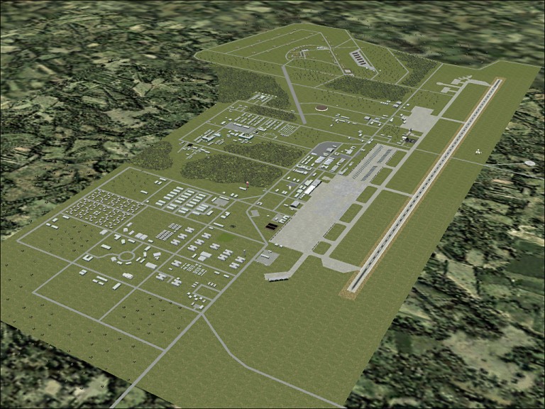 U-Tapao RTAFB: 
|
|
Top
|
|
|
|
|
|
|
| |


 Previous Topic
 Index
Index